Source: Bureau of Meteorology
Media: The Standard Emergency Warning Signal should NOT be used
with this warning.
TOP PRIORITY FOR IMMEDIATE BROADCAST
TROPICAL CYCLONE ADVICE NUMBER 29
Issued at 8:50 am WST on Thursday 13 April 2023
Headline:
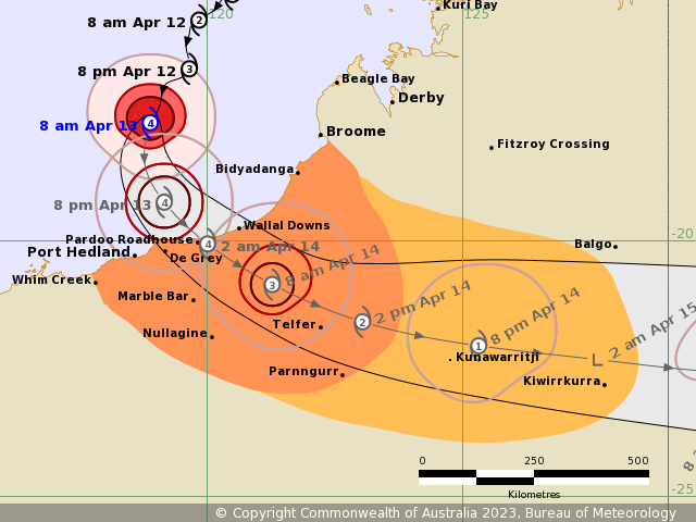
Severe Tropical Cyclone Ilsa, now category 4, is expected to cross
the coast between Port Hedland and Bidyadanga Thursday night or
Friday morning.
Areas Affected:
Warning Zone
Area south of Broome to Whim Creek, including Port Hedland and
extending inland as far as Parnngurr, including Nullagine, Marble
Bar and Telfer.
Watch Zone
Inland areas from Parnngurr to Kiwirrkurra, and southwest of
Balgo.
Cancelled Zone
None.
Details of Severe Tropical Cyclone Ilsa at 8:00 am AWST:
Intensity: Category 4, sustained winds near the centre of 165
kilometres per hour with wind gusts to 230 kilometres per
hour.
Location: within 20 kilometres of 17.7 degrees South 118.9 degrees
East, estimated to be 290 kilometres north of Port Hedland and 295
kilometres northwest of Wallal Downs.
Movement: south southwest at 15 kilometres per hour.
Severe Tropical Cyclone Ilsa has intensified into a category 4
system, and is moving south. Ilsa is expected to turn to the
southeast this afternoon and move towards the east Pilbara
coast.
A severe impact will occur along the coast and adjacent inland
parts to the east of Port Hedland and west of Bidyadanga, most
likely between Pardoo Roadhouse and Wallal Downs, later tonight or
early Friday morning. During Friday, Ilsa is forecast to maintain
tropical cyclone intensity as it tracks past Telfer and further
inland across the Northern Interior district. The system is
expected to weaken below tropical cyclone strength overnight Friday
as it moves east into southern parts of the Northern
Territory.
Hazards:
The VERY DESTRUCTIVE CORE of Ilsa, with extreme gusts up to 275
km/hr is expected to impact the area between De Grey and west of
Bidyadanga late Thursday night or early Friday morning, before
tracking inland. Very destructive wind gusts up to 170 km/hr are
possible at Telfer during Friday if the centre of Isla passes close
by.
DESTRUCTIVE WINDS with gusts to 155 km/h may develop near the
coast between Bidyadanga and Port Hedland during this afternoon or
evening before extending inland as far as Marble Bar tonight and to
Telfer during Friday.
DAMAGING WINDS with gusts to 90 km/h may develop between the area
south of Broome to around Port Hedland from early this afternoon.
DAMAGING winds may extend further west to Whim Creek later today if
Ilsa moves further to the west. DAMAGING WINDS are expected to
extend inland to Marble Bar during Thursday night, to Telfer early
Friday, Parnngurr by Friday afternoon, and possibly to Kiwirrkurra
by Friday evening.
HEAVY RAINFALL and squally thunderstorms are expected over the
western Kimberley, and may extend to the eastern Pilbara during
today and Northern Interior from Friday. 200 to 400 mm of rainfall
is possible during today and Friday near where Ilsa crosses the
coast.
ABNORMALLY HIGH TIDES are possible about the coast between Broome
and Port Hedland today and as the system crosses the coast tonight
or during early Friday morning. In some locations the tide may be
close to or exceed the highest astronomical tide of the year.
Recommended Action:
DFES advises of the following community alerts (effective as of
8am 13/04/2023):
YELLOW ALERT: People between Bidyadanga and Whim Creek including
Port Hedland extending inland to include Marble Bar, Nullagine and
Telfer, people need to act and get ready to shelter from a
cyclone.
BLUE ALERT: People south of Broome to Bidyadanga (not including
Bidyadanga), inland areas to Parnngurr and Kiwirrkurra and from
Roebourne to Whim Creek (not including Whim Creek), need to prepare
for cyclonic weather and organise an emergency kit including first
aid kit, torch, portable radio, spare batteries, food, and
water.
ALL CLEAR: People in or near Beagle Bay to Broome (including
Broome).
Current
Tropical Cyclones